Wireless automated remote deformation monitoring is transforming how engineers collect data to ensure the safety and durability of their projects.
Through a network of interconnected technology, this real-time monitoring system delivers proactive risk management by evaluating structural and geographical deformations. It integrates geotechnical instrumentation such as sensors, data loggers, and gateways with communication networks to automate data processing.
Within such a system, the inclusion of ShapeArrayTM is pivotal for its success.
The importance of geotechnical instrumentation and the evolution of data collection
Automated monitoring and its innovative of digital geotechnical instrumentation represents a departure from traditional manual data collection.
Engineers in the past relied on measurements taken by hand to assess field performance. Today, advanced geotechnical instruments are often deployed in interconnected Industrial Internet of Things (IIoT) systems, automating data collection and transmitting this data wirelessly and remotely.
Different data collection and connectivity solutions
An automated data collection network is the sum of its parts. Meaning it’s crucial to choose geotechnical instruments that will integrate seamlessly, while also delivering the necessary reliability, scalability, and security.
Leveraging ShapeArray with RSTAR Affinity, an integrated system for geotechnical monitoring projects, can provide powerful and streamlined data automation.
ShapeArray
Measurand’s flagship product, ShapeArray is a shape-sensing, inclinometer-style instrument that installs from a reel. Capable of collecting and displaying data in real-time, it’s used to monitor deformation of soil and structures, such as dams, tunnels, walls, and buildings.
When part of a wireless monitoring network, ShapeArray can deliver, wireless, remote, and automated data collection.
RSTAR Affinity
Developed by a team of experts in geotechnical sensor-manufacturing, RSTAR Affinity synergizes remote, wireless data collection with industry-leading instrumentation. It delivers comprehensive support to geotechnical monitoring projects, harnessing the combined power of:
- Data loggers: The RSTAR Affinity Data Logger is a versatile multi-sensor digital node that connects to up to five instruments, offering unprecedented modularity, scalability, and flexibility.
- Gateways: Functioning as a router, the RSTAR Affinity Gateway connects automatically to the self-locating data logger and transmits real-time data to the IT infrastructure.
- Digital suite and mobile app: Simple and intuitive, the RSTAR Affinity Digital Suite offers a browser-based dashboard and companion mobile app to support data visualization and configurable reporting.
RSTAR Affinity offers an end-to-end solution delivering all functions in the data chain from a single source. Integrating this system with ShapeArray creates an incomparable integrated network for wireless automated remote deformation monitoring.
Data collection deployment strategies
Building and maintaining a successful data collection deployment strategy depends on several factors. Some key pre-requisites include:
- Appropriate sensors and devices: Select geotechnical instruments that are suitable for the environmental conditions and data types.
- Reliable connection to power sources. Prevent connectivity dropouts with a battery- or solar-powered setup sized sufficiently for the application.
- Robust wireless networks: Establish stable LoRaWAN, Wi-Fi, and cellular networks (4G/LTE, 5G) equipped to handle data transmission from remote sensors to central servers, even in distant locations or harsh conditions.
- Necessary internal IT. Ensure your organization is equipped to support the remote monitoring system’s operations and processes.
Your automated system will be simple or complex as its project necessitates. However, a basic data collection deployment for slope monitoring could resemble:
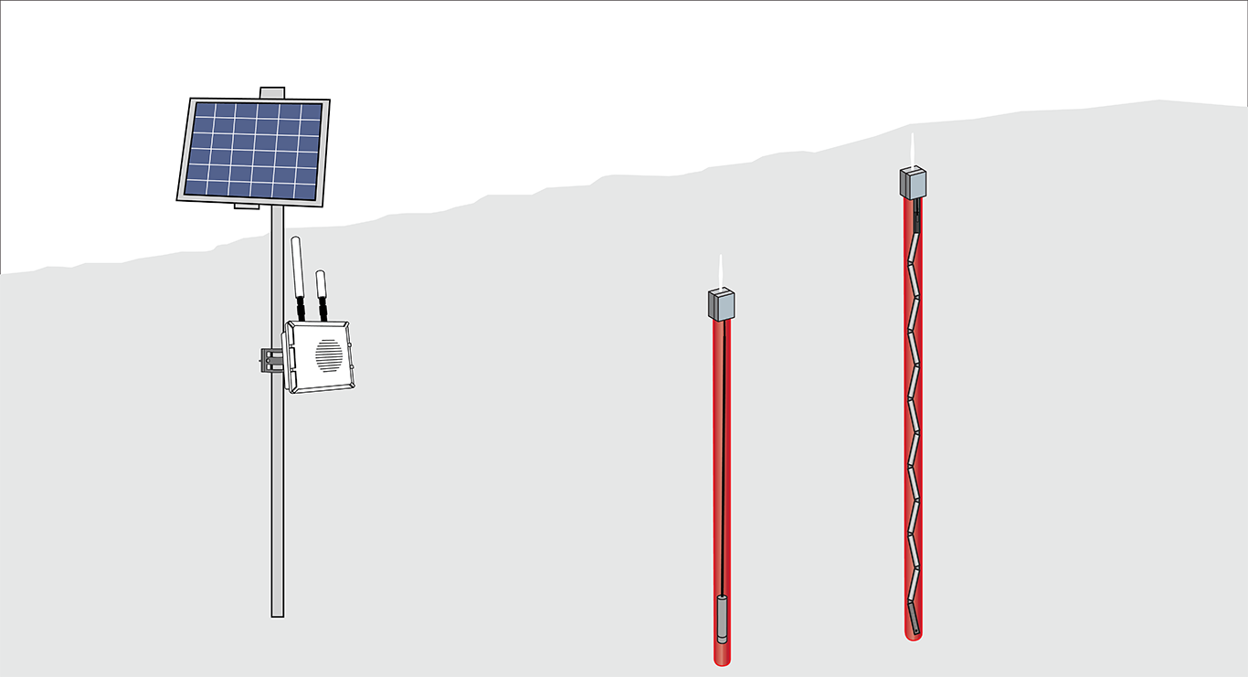
Installed in an inclinometer casing on a slope, the ShapeArray connected to an RSTAR Affinity Data Logger collects deformation data. This data logger periodically collects data from the ShapeArray, transmitting it wirelessly to the RSTAR Affinity gateway that forwards data to a central server or cloud for storage and analysis.
Through this setup, geotechnical engineers can monitor data in real-time to detect early signs of landslides, allowing for timely risk mitigation.
Learn more in our latest webinar
Wondering how automated data collection could fit into your project’s geotechnical monitoring strategy? Watch our recent webinar, “Wireless Automated Remote Deformation Monitoring: How to Get the Most Out of ShapeArray,” hosted by Measurand’s Megan O’Donnell and Terra Insights’ Joseph Cormier.
In this recording, you’ll learn the different ways to approach data collection when using ShapeArray, from standalone manual data collection to the configuration of a fully automated and wireless network of connected data loggers. Discover how slick and easy it can be to deploy and configure a network for data collection.

Speak with an Expert
I’m very happy with the quality of the instrumentation and technical support from RST, as always. They worked with us from the initial stages of the project to ensure that we were fully prepared and equipped to use the RSTAR network for the first time. They delivered everything within the tight project time frame to ensure that there were no delays on site, and the submersible tilt meters looked like new even after over twelve months of being submerged in Thames water!
-Richard Lipscombe, BEng (Hons), Director & Principle Consultant - RL Geotechnical Ltd