In everyday conversation, the terms accuracy and precision have become nearly synonymous, so much so that the average person might be hard-pressed to explain the difference. They might also be surprised to learn that measurements can be accurate without being precise, just as they can be precise without being accurate. (And don’t even get us started on sensitivity or resolution.)
In science and engineering contexts, where efficiency, cost-effectiveness and safety depend on instruments providing reliable data, the seemingly minor difference between the two turns out to be crucial knowledge.
Read on for a quick refresher on accuracy versus precision: we’ll define the terms, illustrate the differences, and then discuss some ways to minimize error and increase data reliability.
What is accuracy?
Accuracy is how close an instrument’s measurements are to the true value being measured. [1] In other words, accuracy is exactly what it sounds like: how correct a measurement is.
When you calibrate an instrument, for instance, you’re aligning its accuracy to a verified, accepted standard of accuracy.
It’s important to remember that no instrument has perfect accuracy. High-grade instruments can come close, but there’s always some uncertainty and error. For this reason, measurements should be expressed alongside a statement of uncertainty. For instance, if an instrument’s accuracy is written as ±1 mm, that means that its results land within 1 millimeter of the true value. In other words, the uncertainty of that instrument is 1 mm. Similarly, an accuracy of ±0.1% means that an instrument’s measurements fall within 0.1% of the true value.
What is precision?
Precision is the repeatability or reproducibility of a measurement’s result. [1] For instance: if conditions remain unchanged, and several measurements are taken, how similar are the results? If an instrument consistently produces very similar results, the instrument is precise.
An instrument’s precision is expressed in the number of significant figures quoted. This means an instrument with a precision of ±0.100 is more precise than a ±0.10 instrument.
That said, just because an instrument’s measurements are repeatable down to the fifth decimal point doesn’t mean that that measurement is accurate.
What’s the difference between accuracy and precision?
In short: precision indicates how close the measured results are to each other; while accuracy indicates how close the measured results are to the truth.
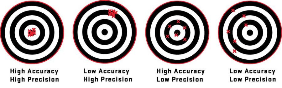
In the diagram above, the bullseye represents the true value of the measurement. Over the course of multiple measurements, the value of an instrument that is both precise and accurate becomes clear.
How to increase accuracy for more reliable data
Highly accurate, highly precise monitoring instrumentation that produces highly reliable data is the goal, of course. But in the field or in the lab, “every measurement involves error and uncertainty.” [1] And in the field, the factors affecting measurement accuracy can be a lot more challenging.
Let’s look at the two types of errors present in measurement: random and systematic, and how to reduce their effects in geotechnical settings.
Random error: (a.k.a. random variation) is always present in measurement. It’s why the least significant digit on a digital display is likely to fluctuate on each reading—even if it seems like no factors have changed between measurements.
The best way to minimize the effects of random error is to take multiple readings with the most precise instrument available, and use the average of the results. This is because the more precise an instrument is, the smaller the variability in its readings.
Systematic error: affects the accuracy of results in predictable and usually constant ways. Fortunately, unlike random error, systematic error is preventable and correctable, so long as we can identify its source. The most common types are:
- Calibration error: A calibration error, or a zero error, happens when an instrument is not calibrated correctly (for instance, a stopwatch that starts at 1.00 second rather than 0.00). Repeated measurements won’t solve this error, but pre-calibrated instruments and expert installation will. Consistent re-calibration, and skilled operators are also necessary.
- Observational error: The skill of the instrument’s operator matters. Increasingly, with technology allowing monitoring to happen automatically and remotely, the chances of a technician recording a 7 instead of 2 are lowered substantially. However, human error still occurs even with the best instrumentation. Hiring well-trained experts who double-check their work helps to prevent this kind of mistake, or catch it early.
- Environmental error: Because geotechnical monitoring rarely happens under controlled conditions, field instrumentation is uniquely susceptible to environmental errors: temperature, pressure, humidity, etc. Sourcing instrumentation that is built to withstand the conditions at play is important, as is recognizing when data has been skewed by these conditions.
- Instrumental error: Every instrument’s accuracy is dependent on the accuracy of each of its components. High-grade instruments that have been thoroughly tested can confidently predict both their accuracy and precision.
By minimizing error as much as possible, we can increase the accuracy and the reliability of data coming from our field observations and monitoring instrumentation. The right instrument, in the right place, operated by the right people, means better data, and better decisions.
[1] J. Dunnicliff, Geotechnical Instrumentation for Monitoring Field Performance. New York: John Wiley & Sons, 1993.
[2] J.R. Taylor, An Introduction to Error Analysis: The Study of Uncertainties in Physical Measurements. New York: University Science Books, 1999.
Speak with an Expert
I’m very happy with the quality of the instrumentation and technical support from RST, as always. They worked with us from the initial stages of the project to ensure that we were fully prepared and equipped to use the RSTAR network for the first time. They delivered everything within the tight project time frame to ensure that there were no delays on site, and the submersible tilt meters looked like new even after over twelve months of being submerged in Thames water!
-Richard Lipscombe, BEng (Hons), Director & Principle Consultant - RL Geotechnical Ltd